The CryoTEMPO-EOLIS data products
- PRODUCT OVERVIEW
- AVAILABLE DATA
- HOW TO CITE
- VERSION HISTORY
EOLIS (Elevation Over Land Ice from Swath) is part of the ESA CryoSat ThEMatic PrOducts (CryoTEMPO) initiative, that aims to support a wide variety of end-users working in the areas of sea ice, polar oceans, land ice, coastal areas and hydrology. The EOLIS products exploit CryoSat’s SARIn mode and the novel swath processing technique to deliver increased spatial and temporal coverage of time-dependent elevation over land ice, a critical metric for tracking ice mass trends.
The data provided by this project aims to:
- Target a wider community of scientific end–users, outside the usual altimetry expert groups (e.g. modellers, Climate/Operational services);
- Be high level (~L2+/CEOS-ARD), user-friendly and simple, including no more than 6-7 parameters including uncertainty estimates;
- Quickly evolve and reflect the most recent scientific outcomes, being generated alongside CryoSat’s core Payload Data Ground Segment (PDGS) products;
- Be easily accessible from a user-friendly interface.
The current release version for the CryoTEMPO-EOLIS data products is: Baseline 2.0.
NB: Baseline 1 data remains available for download, see the Point Product or Gridded Product pages for further details.
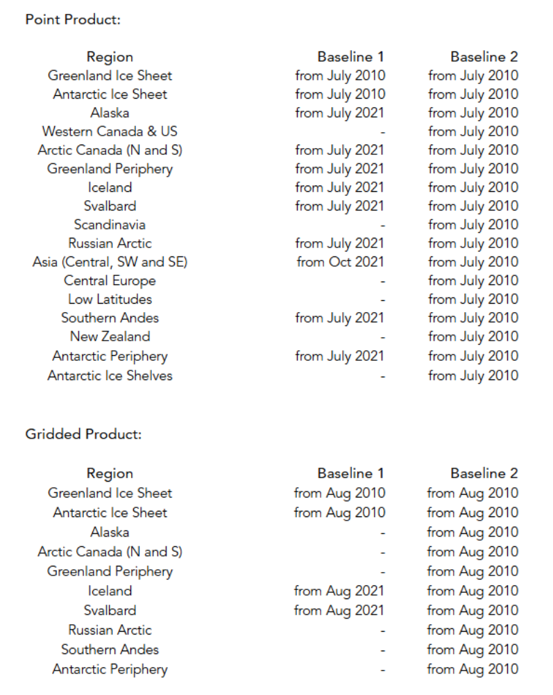
The following tables indicate the temporal coverage of the products.

The recommended citation for the EOLIS product is:
Data over glaciers –
“EOLIS elevation data generated using swath processing of CryoSat-2 data (Jakob & Gourmelen, 2023) and provided by the ESA CryoTEMPO project (https://cryotempo-eolis.org/).”
Jakob, L., and Gourmelen, N., (2023). Glacier Mass Loss Between 2010 and 2020 Dominated by Atmospheric Forcing. Geophysical Research Letters 50(8), 1–10. doi:10.1029/2023GL102954
Data over ice sheets and ice shelves –
“EOLIS elevation data generated using swath processing of CryoSat-2 data (Gourmelen et al., 2018) and provided by the ESA CryoTEMPO project (https://cryotempo-eolis.org/).”
Gourmelen, N., Escorihuela, M., Shepherd, A., Foresta, L., Muir, A., Garcia-Mondejar, A., Roca, M., Baker, S., & Drinkwater, M. R. (2018). CryoSat-2 swath interferometric altimetry for mapping ice elevation and elevation change. Advances in Space Research, 62(6), 1226-1242. https://doi.org/10.1016/j.asr.2017.11.014
Baseline 1:
- 1.1 – Greenland and Antarctic Ice Sheets.
- 1.2 – Addition of the Mountain Glacier regions.
Baseline 2:
- 2.0 – Major Updates:
- Improvements to phase model correction, waveform filtering and uncertainty calibration across all regions.
- Improvements to gridding methods used over Antarctica and Greenland. Additionally, inclusion of gridded uncertainties for these products for the first time.
- The use of RGI 7 glacier masks in all mountain glacier regions.
SUPPORTING DOCUMENTS
Product Handbook
The product handbook acts as a user guide and contains high level algorithm descriptions as well as an overview of file structure:
Algorithm Technical Baseline Document
For more in-depth explanations of underlying algorithms, please refer the Algorithm Technical Baseline Document (ATBD):
Feedback and Queries
Feedback or questions about the CryoTEMPO-EOLIS Thematic Products is welcomed. Please use the following contact details:
E-mail: support@cryotempo-eolis.org


